CITIES
OF MADHYA PRADESH
Amarkantak
Among all the sacred
rivers of India, the Narmada occupies a unique place. Legend has it
that Lord Shiva blessed Narmada with unique purifying powers. Whereas to purify
himself, a devotee requires to take one dip in the Holy Ganga, seven days'
prayers on the banks of Yamuna and three days' prayers on the banks of Saraswati,
the mere sight of Narmada is enough. A charming folk tale describes the
superiority of Narmada over Ganga. Once every year, after she herself is
polluted beyond tolerance, Ganga visits Narmada dressed like a dark woman and
takes a cleansing purifying dip in its waters! There are other rivers too,
popular, romantic and life-sustaining, each glamourized in the folk lore and
history but none can match the mystique of Narmada.
 Situated at an altitude of 1065 mt at the meeting point of the Vindhya
and the Satpura mountain ranges amongst sylvan surroundings, Amarkantak
is a great pilgrim centre for the Hindus, and is the source of the rivers
Narmada and Sone. While the Narmada flows Westwards from Amarkantak, the Sone
flows towards the East. Amarkantak is indeed blessed by Nature. Holy ponds,
lofty hills, forested surroundings, breathtakingly beautiful waterfalls and an
ever-pervading air of serenity make Amarkantak a much sought-after destination
for the religious-minded as well as for the nature-lover.
Situated at an altitude of 1065 mt at the meeting point of the Vindhya
and the Satpura mountain ranges amongst sylvan surroundings, Amarkantak
is a great pilgrim centre for the Hindus, and is the source of the rivers
Narmada and Sone. While the Narmada flows Westwards from Amarkantak, the Sone
flows towards the East. Amarkantak is indeed blessed by Nature. Holy ponds,
lofty hills, forested surroundings, breathtakingly beautiful waterfalls and an
ever-pervading air of serenity make Amarkantak a much sought-after destination
for the religious-minded as well as for the nature-lover.
Top
What to see :
Narmada
Udgam : A
temple built at the source of the Narmada - the holiest spot in Amarkantak.
Sonmuda
:
Source of the river Sone.
Brighu Kamandal
:
Here we can see an ancient Kamandal or
water pitcher which is always full of water.
Dugdhdhara
:
 The water falls from a height of about 50 ft in a
milk-white cascade.
The water falls from a height of about 50 ft in a
milk-white cascade.
Kapildhara
:

A beautiful picnic spot and a waterfall.
Mai Ki Bagiya
:
A
lovely garden with a temple.
Top
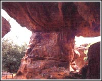
Bandhavgarh
 Prior to becoming a
National park, the forest around Bandhavgarh had long been
maintained as a Shikargah, or game preserve, of the Maharajahs
of Rewa. Hunting was carried out by the Maharajahs and their guests-
otherwise the wildlife was relatively well-protected.
Prior to becoming a
National park, the forest around Bandhavgarh had long been
maintained as a Shikargah, or game preserve, of the Maharajahs
of Rewa. Hunting was carried out by the Maharajahs and their guests-
otherwise the wildlife was relatively well-protected.
It was considered a good omen for a Maharajah of Rewa to shoot 109 Tigers. His
highness Maharajah Venkat Raman Singh shot 111 Tigers by 1914.
This is a small National Park; compact, yet full of game. The density of the
Tiger population at Bandhavgarh is the highest known in India.
This is also White Tiger country. These have been found in the
old state of Rewa for many years. The last known was captured by Maharajah
Martand Singh in 1951. This White Tiger, Mohun, is now stuffed
and on display in the palace of the Maharajahs of Rewa.
Top
Covering 448 sq km, Bandhavgarh is situated in Shahdol district among the
outlying hills of the Vindhya range. At the centre of the park is Bandhavgarh
hill, rising 811 mt above MSL. Surrounding it are a large number of smaller
hills separated by gently sloping valleys. These valleys end in small, swampy
meadows, locally known as 'Bohera'. The lowest point in the park is at
Tala (440 mt above MSL). The vegetation is chiefly of Sal forest in the valleys
and on the lower slopes, gradually changing to mixed deciduous forest on the
hills and in the hotter, drier areas of the park in the south and west. Bamboo
is found throughout.
What to see :
The Fort
:
 No records remain to show when Bandhavgarh Fort was constructed. It is thought,
however, to be some 2,000 years old, and there are references to it in the
ancient books, the Narad-Panch Ratra and the Siva Purana. Various dynasties have
ruled this fort: for example, the Maghas from the 1st century AD, the Vakatakas
from the 3rd century; the Sengars from the 5th century and the Kalchuris from
the 10th century. In the 13th century AD, the Baghels took over, ruling from
Bandhavgarh until 1617, when Maharajah Vikramaditya Singh moved his capital to
Rewa. The last inhabitants deserted the fort in 1935.
No records remain to show when Bandhavgarh Fort was constructed. It is thought,
however, to be some 2,000 years old, and there are references to it in the
ancient books, the Narad-Panch Ratra and the Siva Purana. Various dynasties have
ruled this fort: for example, the Maghas from the 1st century AD, the Vakatakas
from the 3rd century; the Sengars from the 5th century and the Kalchuris from
the 10th century. In the 13th century AD, the Baghels took over, ruling from
Bandhavgarh until 1617, when Maharajah Vikramaditya Singh moved his capital to
Rewa. The last inhabitants deserted the fort in 1935.
The Flora & Fauna:The forest
of Bandhavgarh can be classified as moist deciduous, and the National Park holds
all those animal species which are typical of this habitat in Central India.
Certain areas of the park (particularly the south and the west) are drier in
character, and hold such species as the Nilgai and the Chinkara.
Top
Wildlife :
 Bandhavgarh
is densely populated with tiger and other wildlife species. The great
Gaur, or Indian Bison, can be seen with ease, as they
come onto the meadows to graze at dusk; Sambar and Barking Deer are a common
sight, and Nilgai are to be seen in the more open areas of the park.
Bandhavgarh
is densely populated with tiger and other wildlife species. The great
Gaur, or Indian Bison, can be seen with ease, as they
come onto the meadows to graze at dusk; Sambar and Barking Deer are a common
sight, and Nilgai are to be seen in the more open areas of the park.
There are more than 22 species of mammals and 250 species of birds. Common
Langurs and Rhesus Macaque represent the primate group. Carnivores include the
Asiatic Jackal, Bengal Fox, Sloth Bear, Ratel, Gray Mongoose, Striped Hyena,
Jungle Cat, Leopard and Tiger. The artiodactyls frequently sighted are Wild
Pigs, Spotted Deer, Sambar, Chausingha, Nilgai, Chinkara and Gaur. Mammals such
as Dhole, the small Indian Civet, Palm Squirrel and Lesser Bandicoot Rat are
seen occasionally. Among the herbivores, Gaur is the only coarse feeder.
Wildlife Viewing :
There are two main ways of
getting about in the park- in a motor vehicle or on elephant back. Many of the
animals are now accustomed to both; even so, it is best to talk quietly and not
make rapid movements.
 Jeep safaris are best undertaken from dawn until about 10am and from about 4pm
until dusk, as the animals are most active during these periods. A Forest
Department guide must always accompany you. This guide will be able to direct
you and point out wildlife.
Jeep safaris are best undertaken from dawn until about 10am and from about 4pm
until dusk, as the animals are most active during these periods. A Forest
Department guide must always accompany you. This guide will be able to direct
you and point out wildlife.
Elephants are used every morning by the Forest Department for Tiger- tracking.
If a Tiger is found, then the elephant will take you directly to the Tiger
either from the lodge or from a nearby point reached by jeep/car.
Click on the Image to know more
about this place and booking details!!
Top
Bhedaghat
 In his Highlands of
Central India Captain J. Forsyth speaks eloquently about the infinitely varied
beauty of the rocks :
In his Highlands of
Central India Captain J. Forsyth speaks eloquently about the infinitely varied
beauty of the rocks :
"the eye never wearies of the . . . effect produced by the broken
and reflected sunlight, now glancing from a pinnacle of snow-white marble reared
against the deep blue of the sky as from a point of silver, touching here and
there with bright lights the prominence of the middle heights and again losing
itself in the soft bluish grays of their recesses. . .
Here and there the white saccharine limestone is seamed by veins of dark green
or black volcanic rock; a contrast which only enhances like a setting of jet,
the purity of the surrounding marble."
The holy river flows by tranquilly flanked by the towering cliffs which
reflect in it like a mirror the changing moods of nature. A little distance
away, it becomes turbulent as it plunges in a mighty water fall known as
Dhuandhar.
Top
What to see :
Dhuandhar Falls :
 The
Narmada, making its way through the marble rocks, narrows down and then plunges
in a waterfall known as Dhuandhar or Smoke Cascade. So powerful is the plunge
that its roar is heard from a far distance. The falls and the breaking of the
volume of water at the crest present an awesome spectacle of Nature's power
unleashed.
The
Narmada, making its way through the marble rocks, narrows down and then plunges
in a waterfall known as Dhuandhar or Smoke Cascade. So powerful is the plunge
that its roar is heard from a far distance. The falls and the breaking of the
volume of water at the crest present an awesome spectacle of Nature's power
unleashed.
Chaunsat Yogini Temple :
Situated
atop a hillock and approached by a long flight of steps, the Chaunsat Yogini
Temple commands a singularly beautiful view of the Narmada flowing through the
jagged Marble Rocks. Dedicated to goddess Durga, this 10th century temple has
exquisitely carved stone figures of deities belonging to the Kalchuri period.
According to a local legend, this ancient temple is connected to the Gond Queen
Durgavati's palace through an underground passage.
Marble Rocks :
 Boating facilities
are available from November to May and while boating by moonlight is a thrilling
experience, the Marble Rocks have recently been floodlit, adding a new dimension
to their splendour.
Boating facilities
are available from November to May and while boating by moonlight is a thrilling
experience, the Marble Rocks have recently been floodlit, adding a new dimension
to their splendour.
Top
BHIMBETKA
Surrounded
by the northern fringe of the Vindhyan ranges, Bhimbetka lies 46 km South of
Bhopal. In this rocky terrain of dense forest and craggy cliffs, over 600 rock
shelters belonging to the Neolithic age were recently discovered. Here, in vivid
panoramic detail, paintings in over 500 caves depict the life of the
pre-historic cave-dwellers making the Bhimbetka group an archaeological
treasure, an invaluable chronicle in the history of man.
Places to Visit
The
superimposition of paintings shows that the same canvas was used by
different people at different times. The drawings and paintings can be
classified under seven different periods:
Top
Period I - (Upper Paleolithic)
These are linear representations, in green and dark red, of huge figures
of animals such as bisons, tigers and rhinoceros.
Period II - (Mesolithic)
Comparatively small in size, the stylized figures show linear
decoration of the body. In addition to animals, there are human figures
and hunting scenes, giving a clear picture of the weapons they used -
barbed spears, pointed sticks, bow and arrows. The depiction of communal
dances, birds, musical instruments, mother and child, pregnant women, men
carrying dead animals, drinking and burials appear in rhythmic movement.
Period III - (Chaleolithic)
Similar to the paintings of Chaleolithic pottery, these drawings reveal
that during the period, the cave dwellers of this area had come in contact
with the agricultural communities of the Malwa plains and started an
exchange of their requirements with each other.
Period IV & V - (Early History)
The figures of this group have a schematic and decorative style, and
are painted mainly in red, white and yellow. The association is of riders,
depiction of religious symbols, tunic-like dresses and the existence of
scripts of different periods. The religious beliefs are represented by
figures of yakshas, tree gods and magical sky chariots.
Period VI & VII - (Medieval)
These paintings are geometric, linear and more schematic, but show
degeneration and crudeness in their artistic style.
Top
Bhojpur
The lingam in the
sanctum rises to an awe-inspiring height of 7.5 feet with a circumference of
17.8 feet. Set upon a massive platform 21.5 feet square, and composed of three
superimposed limestone blocks, the architectural harmony of lingam and platform
creates a superb synthesis of solidity and lightness.
Founded by the legendary Parmar King of Dhar, Raja Bhoj
(1010-1053), and named after him, Bhojpur, 28 km from Bhopal,
is renowned for the remains of its magnificent Shiva temple and Cyclopean dam.
The temple which has earned the nomenclature of the Somnath of the east, is
known as the Bhojeshwar Temple. The temple was never completed and the
earthen ramp used to raise it to dome-level still stands. Had it been completed,
it would have had very few rivals. As it is, even with the ravages of time, it
remains one of the best examples of temple architecture of the 11th - 13th
centuries.
Top
What to see :
Bhojeshwar Temple
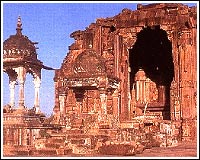 In plan, a
simple square with an exterior dimension of 66 feet, it is devoid of the
re-entrant angles usual in such buildings. The richly carved dome though
incomplete has a magnificent soaring strength of line and is supported
by four pillars. These like the dome have been conceived on a massive
scale, yet retain a remarkable elegance because of their tapering form.
Divided into three sections, the lowest is an octagon with facets of
2.12 feet, from which springs a 24-faced section.
In plan, a
simple square with an exterior dimension of 66 feet, it is devoid of the
re-entrant angles usual in such buildings. The richly carved dome though
incomplete has a magnificent soaring strength of line and is supported
by four pillars. These like the dome have been conceived on a massive
scale, yet retain a remarkable elegance because of their tapering form.
Divided into three sections, the lowest is an octagon with facets of
2.12 feet, from which springs a 24-faced section.
Jain Temple:
Also,
incomplete, and with a similar stone-raising ramp, is a Jain shrine that
stands close to the Bhojeshwar temple. Three figures of the tirthankaras
are contained within; one of a colossal statues of Mahavira 20 feet
high, and the other two of Parswanath. Rectangular in plan, this temple
probably belongs to the same period as the Bhojeshwar.
Cyclopean Dam:
West
of Bhojpur once lay a vast lake, but nothing remains except the ruins of
the magnificent old dams by which its waters were contained. The site
was chosen with great skill, as a natural wall of hills enclosed the
whole area except for two gaps, 100 yards and 500 yards in width
respectively. These were closed by gigantic earthen dams, faced on both
sides with enormous blocks of sandstone, many being 4 feet long, 3 feet
broad, and 2.5 feet thick, set without mortar. The smaller dam is 44
feet high and 300 feet thick at the base, the larger dam 24 feet high
with a flat top 100 feet broad. These embankments held up an expanse of
water of about 250 square miles. This great work is ascribed to Raja
Bhoj, but it may possibly be of an earlier date.
Top
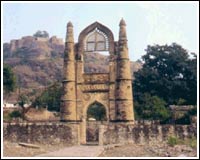
Chanderi
The documented
history of Chanderi goes back to the early11th century and is a kaleidoscope of
movement and activity prompted by its strategic location. On the borders of
Malwa and Bundelkhand, the town dominated the trade routes of Central India and
was proximate to the arterial route to the ancient ports of Gujarat as well as
to Malwa, Mewar, Central India and the Deccan. Consequently, Chanderi became an
important military outpost, prized by rulers with power or ambition, and
repeatedly experienced the might of men who moulded the destiny of Hindustan.
Places to See
Chanderi is surrounded by
hills, lakes and forests, and there are several monuments of Bundela Rajputs
and Malwa Sultans. Noteworthy among them are :
The Fort
Dominating the skyline of this lovely old town, is a Mughal fort. The vast
fort was built on a 200 metre high hill during the Mughal period. Its main
gate is known as the "Khooni Darwaza".
Top
Koshak Mahal
According to historical records, Koshak Mahal was ordered to be built by
Mahmud Khilji of Malwa when he passed through Chanderi in 1445 AD. The
original plan of the Khilji ruler was to construct a seven-storey palace
though only two could be completed during his life time. The Mahal is divided
into four equal parts and has architecture similar to Mandu.
Badal Mahal Gate
A gate without a Mahal, it was constructed to commemorate some important
victory.
Jama Masjid
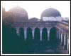 With imposing domes and long arcades, this is possibly the biggest mosque
of the erstwhile Madhya Bharat State.
With imposing domes and long arcades, this is possibly the biggest mosque
of the erstwhile Madhya Bharat State.
Shahzadi Ka Rouza
The name is attributed to some unknown princess. The building is decorated on
the exterior with ornamental arches and a band of geometrical designs.
Top
Parameshwar Tal
Built by Bundela Rajput Kings, the picturesque Parameshwar tank is situated
half a mile to the north-west of Chanderi town. It has on its bank a
well-carved temple and cenotaphs of three Rajput Kings.
Battisi Bavdi
Built by Sultan Ghiyasuddin Shah in 1485, the Battisi Bavdi derives its name
from a flight of thirty two steps.
Buddhi (Old) Chanderi
The old Chanderi city has a number of Jain temples of 9th and 10th centuries.
It attracts thousands of Jain pilgrims from all parts of the country every
year.
Thruvanji
26 km South-West of Chanderi is the old village of Thruvanji. The village has
a number of Jain temples of the early medieval period.
Top
Chattisgarh&Bastar
Bastar
is tribal country. The Gonds in Bastar remain perhaps the least in contact with
the world outside due to the remoteness and ruggedness of the terrain. It is
also the home of the Marias and the Murias who have preserved
very remarkably their distinct way of life in small isolated communities. These
are the indigenous people of Madhya Pradesh whose customs and beliefs are still
intact.
The history of Chhattisgarh can be traced back to very early
times when it was known as South Kosala. The
Aryan migrants to the South passed through it. It was a cradle of highly
interesting experiments in art and culture. Recent archaeological excavations
conducted in the area have led to discoveries of a wealth of inscriptions and
coins which throw a flood of light on the history and culture of South Kosala.
Raipur and Bilaspur are the most convenient bases for visiting
all major places of tourist interest in the area. Both these cities are vibrant
commercial centres and occupy positions of prominence in Madhya Pradesh.
Top
What to see :
Bhoramdeo
: Situated at a
distance of 18 km from Kawardha on the Raipur (116 km) Jabalpur (220 km) road on
the banks of the river Sankari among the Satpura hills and their scenic valleys,
the Bhoramdeo temples have a special attraction for lovers of history and
archaeology.
The temples were built by the celebrated King Ramachandra of the Nag
dynasty, who married Princess Ambikadevi of the Hayahaya dynasty. The temples
are superb examples of contemporary architecture and have much historical,
religious and archaeological importance. In an area of 5 km in the palaces of
Manwa and Madanmanjari are erotic sculptures similar to those in Khajuraho
temples.
Bastar :
Predominantly a forest area, Bastar is the home of Marias and Murias, both
extremely colourful and picturesque tribes, who have preserved their ancient
culture.
Jagdalpur :The
colourful festival of Dusshera is celebrated here on a grand scale every year.
Chitrakote Falls : Situated
38 km from Jagdalpur at a spot where the river Indrawati has a fall of 96 ft.
Top
Chitrakoot
 Sufferers and seekers, poets and
visionaries, princes and noblemen have, through the ages, sought and found
solace in Chitrakoot, drawn inspiration from its sublime natural beauty, gained
spiritual strength from its serene temples and in turn, become part of the
hallowed legend that is Chitrakoot.
Sufferers and seekers, poets and
visionaries, princes and noblemen have, through the ages, sought and found
solace in Chitrakoot, drawn inspiration from its sublime natural beauty, gained
spiritual strength from its serene temples and in turn, become part of the
hallowed legend that is Chitrakoot.
Chitrakoot, 'the hill of many wonders', nestles
peacefully in the northern spurs of the Vindhyas, a place of tranquil
forest glades and quiet rivers, and streams where calm and repose are all
pervading. This loveliest of Nature's gifts is also hallowed ground, blessed by
the gods and sanctified by the faith of pilgrims. For Chitrakoot's spiritual
legacy stretches back to legendary ages: it was in these deep forests that Rama
and Sita spent eleven of their fourteen years of exile; here that the great sage
Atri and Sati Anusuya meditated; and here where the principal trinity of the
Hindu pantheon, Brahma, Vishnu and Mahesh, took their incarnations.
What to see :
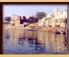
Ramghat : The
ghats that line the banks of the river Mandakini reveal a constantly
moving and changing kaleidoscope of religious activity. Here, amidst the
chanting of hymns and the sweet fragrance of incense, holy men in saffron robes
sit, in silent meditation or offer the solace of their wisdom to the countless
pilgrims who converge here. With the very first rays of dawn that gleam upon the
river, Ramghat stirs into life as the devout of all ages take the ritual,
purifying dip in the waters and invoke the blessings of the gods. The rippling
blue green waters of the Mandakini can be traversed by boats, readily available
for hire.
Kamadgiri : Kamadgiri,
the original Chitrakoot, is a place of prime religious significance. A
forested hill, it is skirted all along its base by a chain of temples and is
venerated, today, as the holy embodiment of Rama.
Top
The Bharat Milap temple is located here, marking the spot where
Bharat is said to have met Rama to persuade him to return to the throne of
Ayodhya. Many are the faithful who perform the ritual circuit (Parikrama), of
the sacred hill, to ask for a boon or a blessing.
Sati Anusuya : Sati
Anusuya
is located further up-stream, set amidst thick forests that resound to the
melody of birdsong all day. It was here that Atri Muni, his wife Anusuya and
their three sons (who were the three incarnations of Brahma, Vishnu and
Mahesh) are said to have meditated. The Mandakini is believed to have been
created by Anusuya through her meditation. Sati Anusuya lies about 16 km from
the town and can be reached by road - an undulating, curving drive through
densely wooded areas.
Sphatik Shila : A
few kilometers beyond Janaki Kund is again a densely forested area on
the banks of the Mandakini. One can climb up to the boulder which bears the
impression of Rama's footprint and where Sita was pecked at by Jayant in the
form of a crow. There are large fish in the river here easily visible in the
pellucid water, and a few temples.
Janaki Kund : In
this idyllic pastoral setting, it is said, Sita would bathe in the crystal clear
waters, during the years of her exile with Rama. Certainly, this quite spot
seems to have been specially blessed, for an aura of total harmony and
quietitude haloes it, setting it apart from the bustle of the everyday world.
Gupt-Godavari : 18
km from the town is a natural wonder located some distance up the side of a
hill. The wonder here is a pair of caves, one high and wide with an entrance
through which one can barely pass, and the other long and narrow with a stream
of water running along its base. It is believed that Rama and his brother Laxman
held court in the latter cave, which has two, natural throne-like rocks.
Top
Site Designed & Produced by Ashex
Gething Morgan DotCom